In map-making, "projection" simply refers to the method of translating geographic data onto a flat surface. It does not mean taking one map and placing it onto another. Instead, it involves using a specific technique to represent distances and directions from a reference point on a flat map. The projection defines how spatial information is mathematically converted into a two-dimensional format.
The azimuthal equidistant projection map is created by following these steps:
1.
Central Point Selection: Choose a central point on the Earth's surface. This point serves as the origin from which distances and directions are measured.
2.
Distance Measurement: Measure the distances between the central point and various other locations on the Earth's surface using terrestrial methods. These measurements are done directly on the ground and not based on any spherical assumptions.
3.
Projection Application: Use the azimuthal equidistant projection to map these distances onto a flat surface. This projection preserves the proportional distance from the central point to other locations. It also maintains the correct direction from the center to these locations.
4.
Mapping Process: Transfer the measured distances and directions onto the flat map. The central point is placed at the center of the map, and the distances to other points are scaled proportionally according to the projection's formula.
5.
Map Accuracy: The resulting map accurately reflects the distances and directions from the central point based on the measurements. The projection ensures that distances from the central point are correct.
An azimuthal equidistant projection map is made by measuring real-world distances from a central point, applying these measurements to a flat surface, and ensuring that distances and directions are accurately represented.
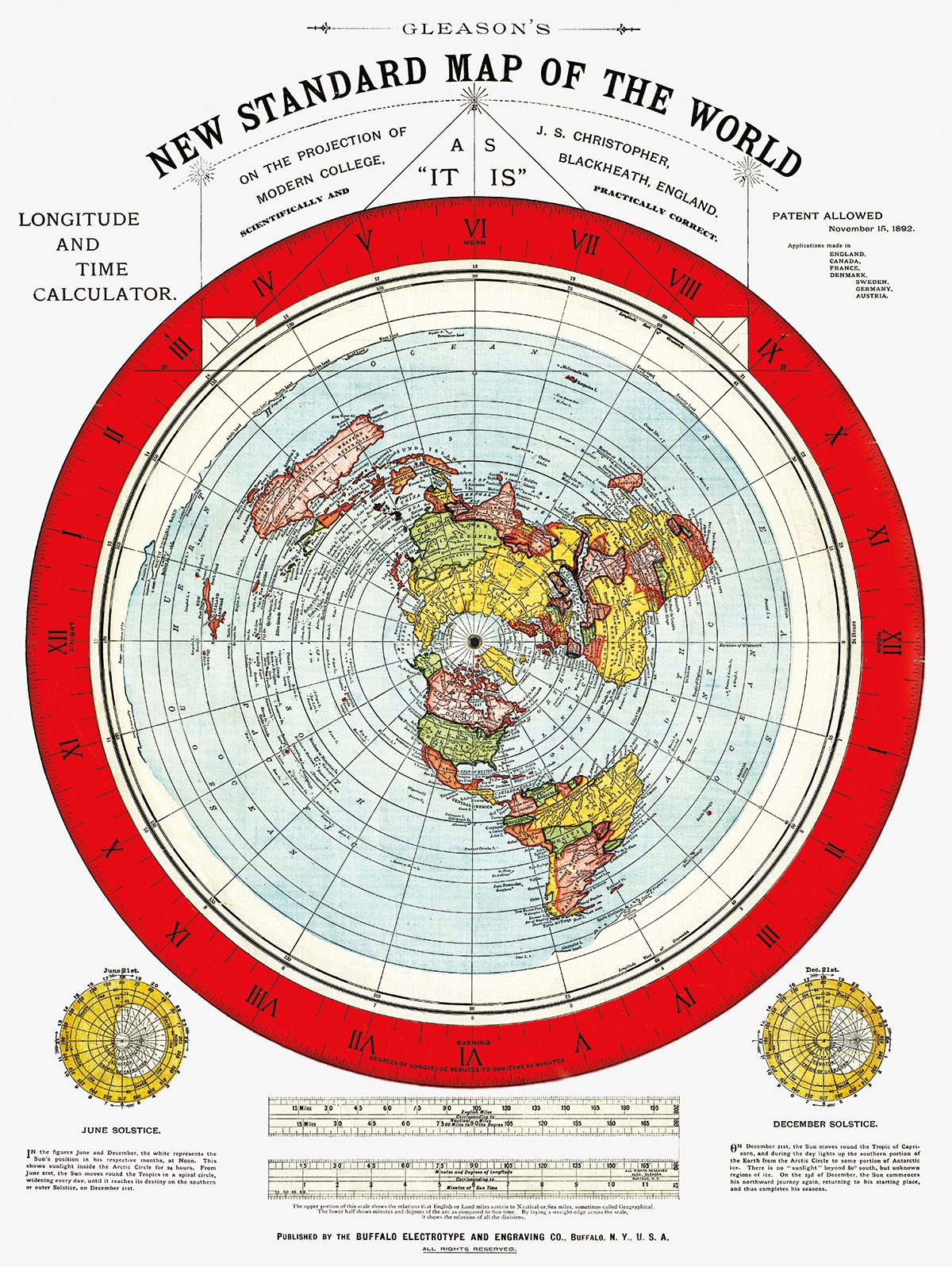
The process Alexander Gleason used to create his map:
https://files.catbox.moe/syz6od.jpg![]() Projection Accuracy
Projection Accuracy: Alexander Gleason's map utilizes the azimuthal equidistant projection, which accurately represents distances from a central point, maintaining correct proportionality. This projection is effective for mapping distances and directions on a flat surface.
Empirical Measurements: Gleason's map was created using detailed empirical data, measuring real-world distances between landmarks. His method involved careful data collection and accurate representation of these distances on his map.
Consistency with Observations: The distances and spatial relationships depicted on Gleason's map align with observed patterns and measurements on the Earth's surface. This consistency supports the accuracy of the map in representing a flat, stationary plane.
Modern Utilization: Modern maps that use the azimuthal equidistant projection for navigation and other purposes validate the effectiveness of this projection. If Gleason's map, which uses the same projection, is accurate in these contexts, it confirms that the map reliably represents distances on a flat surface.
Accurate Representation: The fact that Gleason's map, based on empirical data and a valid projection, shows accurate distances and spatial relationships indicates that his representation of the world is correct. This accuracy supports the view that the map accurately depicts a flat Earth.
Alexander Gleason's map is accurate in representing distances and spatial relationships based on the azimuthal equidistant projection and empirical data. The consistency of these representations and the use of the projection in modern maps support the conclusion that his map correctly depicts a flat Earth.
So the idea that Alexander Gleason used a projection of a globe map is retarded. It is called the Gleason's map because Gleason made the map. It is called a projection because all maps are a projection. What kind of projection is it? It's an azimuthal equidistant projection which has absolutely nothing to do with a globe.
There doesn't seem to be anything here yet